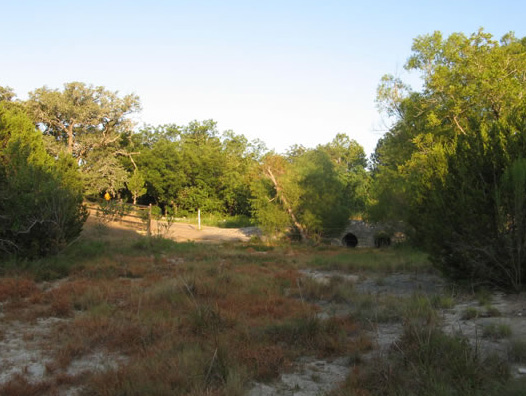
Current bridge:
Bridge/Entrance Improvement Project – Information for Residents View survey results here
Prepared by Margaret Paine, with input from Anne Danish, GWW representatives to the tri-community Bridge Project Oversight Committee (OSC). Note: Questions and requests for additional information may be directed to Delbert Bassett and the other OSC members via the webmaster.
A few initial facts
As of the date of this entry (1 Sep 2012), the delay of the entrance improvement project is because of AT&T. There are some cables which have caused a problem. The county is waiting on AT&T to resolve the issue.
TxDOT has presented us with a design for an improvement to our entrance, around and including our sign at FM 1826, in cooperation with representatives from all the communities “at the top of the hill”. It will include all native plants, and has met with the approval of the community representatives. A diagram is available upon request.
Terms
Bridge
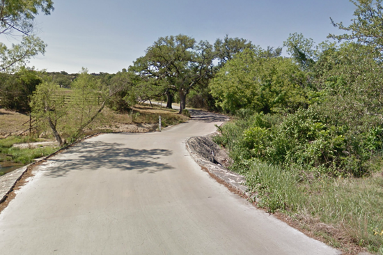
We're using this term to indicate the actual structure spanning the creek, as well as the roadway from it to FM 1826 and on the hillside up to the three large live oak trees which arch over the roadway.
1% and 4%
A 1% bridge, also called a 100 year bridge, is one which in any given year has a 1% probability of being topped by flood waters. A 4% bridge, also called a 25 year bridge, is one which in any given year has a 4% probability of being topped by flood waters. So, odds are that a 1% bridge would likely flood once every 100 years, whereas a 4% bridge would likely flood once every 25 years.
Our current bridge is a 50% bridge, subject to flooding about once every other year.
The TxDOT standard for a bridge is a 25 yr (4%) bridge. The Hays County standard is a 10 yr (10%) bridge.
Project
The original bond issue, which voters passed, was for a left turn lane from FM 1826 onto Crystal Hills. When the area was reviewed, TxDOT found that the steep incline from Crystal Hills Rd up to FM 1826 was not up to TxDOT's standards. Substandard intersections are corrected when other work is necessary. The county had money left over from other bonds issues, so they decided to use it to replace our flood-prone bridge. The county appointed TxDOT as the lead for the improvement project.
The original direction from the county to the designing engineer was to give us a 10% bridge that saves the large oak trees. Instead, the bridge design engineer drew a level, constant elevation line from the edge of FM 1826 to the point where it intercepts Crystal Hills Drive (approximately 60 feet uphill from the large live oak trees), and produced the “1% bridge” design.
1% Bridge Design
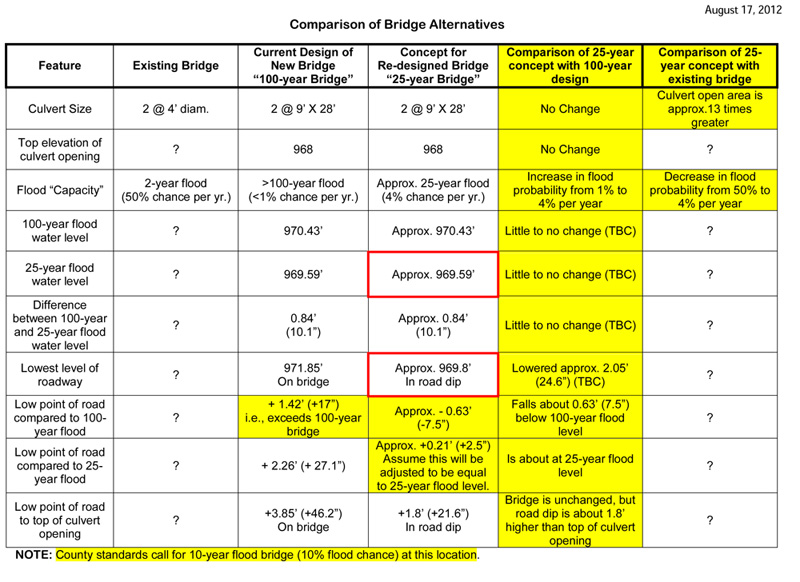
The bridge currently approved by the county and under contract to be constructed has the following features:
- A 1% or maybe even a 0.5% flood probability; water from a 100 year storm event will be 17 inches short of topping the bridge/road
- The road as it passes the large live oak trees would be at a height that would require retention walls and guard rails both having penetration down to bedrock.
- With this design the roadway would be 28 feet wide from FM 1826 to a point on Crystal Hills Dr uphill of the three live oak trees.
- The westernmost live oak would need to be removed to accommodate the wider roadway, and Don Gardner, certified arborist, has informed us that the retaining wall and its footings on the east side would threaten the survival of the two large live oaks on that side.
4% Bridge Design
Asked to give us a modification of this original design which would not endanger the three large live oak trees, the engineers proposed a redrawn profile. This is the “4% bridge”. This revision of the first design has the following features:
- The roadway and bridge are identical to the 1% design from FM 1826 to just past the midpoint of the bridge, then the roadway gently dips about two feet, and finally rises back up to join the uphill slope of the roadway, beyond the location of the three large oak trees.
- The bridge over the creek is nearly unchanged, however the dip in the roadway on the south side of the bridge gives this design a 4% flood probability.
- It would eliminate the need for a retaining wall beside the three large live oak trees, and therefore would offer a higher probability that these trees would survive.
With this design, the roadway would be 28 feet wide from FM 1826 to the point where it passes between the three live oak trees. At that point it would narrow; the width of the roadway at that point is unknown because this design has not yet been formally drawn by the designer. However we are led to believe that the width will be between 21 and 22 feet. The width will be reduced by the thickness of the guard rails which are required on both sides of the road.
Currently the roadway in the vicinity of the bridge and three live oak trees varies in width between 21 and 22 feet.
(The Hays County road standard for a minor collector road with up to 2500 trips/day, at 35 mph, is 22’ wide).
Additional facts to note
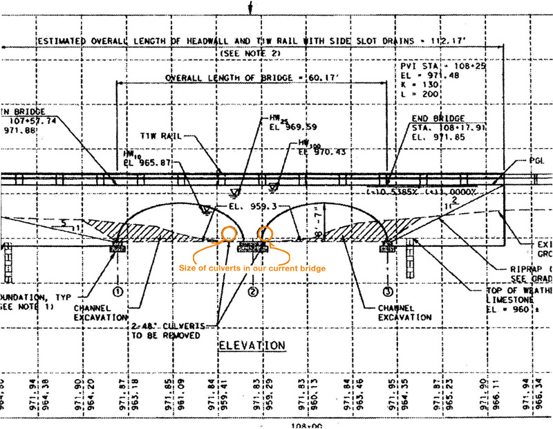
Currently, the two culverts under our bridge are 48 inches in diameter each. With either of the improved bridge designs, these will be replaced by two culverts measuring 9 feet high and 28 feet across (see diagram on page 4). This feature is the same for both bridge designs.
With either bridge, water in a flood event will clear the roadway much more quickly because of the greater capacity of the culverts.
For either bridge design, Cor-Ten steel will be used on bridge rails, possibly guard rails. This is a steel which oxidizes to a natural brown color, suggestive of wood material, instead of the galvanized steel more commonly used in highway guard rails.
Some residents have asked whether the large oak trees would need to be trimmed to accommodate truck traffic on the elevated roadway. The southernmost oak tree would need minor trimming if the 1% bridge is built, but this would not threaten the life of the tree. No trimming should be needed with the 4% bridge.
There is no true acceleration lane for eastbound traffic out of the subdivision, but a wider than usual shoulder will be provided. Left-turn lane into the neighborhood will have the same capacity as the turn lane for Nutty Brown Rd.
Below is a diagram of the proposed bridge.
A Survey was conducted between 18 August and 27 August to gather feedback from the Goldenwood West community regarding their preferences between the 1% bridge option and the 4% bridge options. Responses were received from residents representing 52 lots. The results were:
In favor of the 4% bridge option: 42
In favor of the 1% bridge option: 10
One respondent abstained from taking a position.
The complete results (in three documents) may be downloaded here: Information Session Survey Results, Email Survey Results, and Late Submission Email Survey Results.
|


